Short answer, as of 31 October 2026: Albay is not closed, but the volcano itself is off-limits, and this is a bad week to plan a Mayon trip around the mountain. Mayon erupted at 11:53 a.m. on Friday, 30 October, and PHIVOLCS raised it from Alert Level 2 back to Alert Level 3 within the hour. Evacuations are under way inside the 6-kilometer Permanent Danger Zone, ATV rides are restricted to the Cagsawa Ruins area, and the Mayon Skyline road is shut until further notice.
Legazpi City, the airport area and most of the province outside the danger zone are still lived in and working. Whether you should go depends on what you came for. If the trip is about the volcano up close, postpone. If it is about the food, the city and a view of Mayon from a safe distance, you can still go, as long as you accept ash, changing rules and possible flight disruption.
This page covers what happened on 30 October, what Alert Level 3 means in practice, which activities are open or closed, and how to decide whether to keep, move or cancel a booking.
What Happened on 30 October
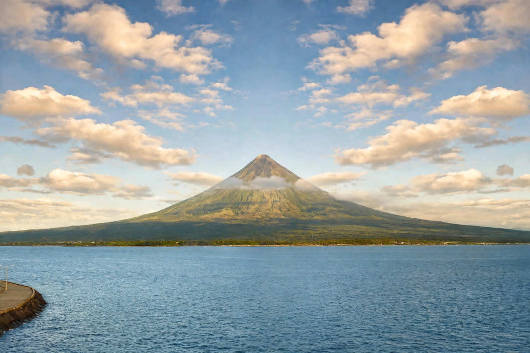
The eruption lasted about six minutes. PHIVOLCS described it as moderately explosive and said the volcano had entered a new phase of magmatic eruption. A grey ash column rose roughly 3,000 meters above the crater and drifted west-southwest, toward Camalig, Guinobatan and Daraga. Ash also fell on the upland parts of Legazpi City, and Guinobatan was among the worst hit.
Albay Governor Noel Rosal suspended classes at all levels in public and private schools that afternoon and ordered strictly no human activity inside the 6-kilometer zone. Camalig and Tabaco City began moving families out right away, and the province prepared to shelter more than 1,100 families from eight towns and cities around the volcano. Police and army units are guarding the entry points.
This came less than three months after a long stretch of unrest. Mayon was first raised to Alert Level 3 on 6 January 2026 after its summit lava dome collapsed, and lava kept flowing down its gullies for most of the first half of the year. PHIVOLCS lowered the status to Level 2 in early August, with a warning that the lower level did not mean the unrest was over. The 30 October eruption showed why.
What Alert Level 3 Means on the Ground
PHIVOLCS uses a scale from 0 to 5. Level 3 means an increased tendency toward a hazardous eruption within days to weeks. For Mayon, the main dangers are lava flows, rockfalls and pyroclastic density currents, the fast, scorching avalanches of gas and rock that locals call uson. These can sweep down the upper and middle slopes with little warning. Heavy rain adds a second risk, lahar, when loose ash and rock on the slopes turn into mudflows along river channels.
For a visitor, Level 3 means three practical things. The 6-kilometer zone is closed to everyone, including guides and farmers. Tour operators are working under provincial rules that can tighten overnight. And the province's attention is on evacuees, so expect checkpoints, slower roads and busy local offices.
What Is Open and What Is Closed
Closed or restricted
Anything inside the Permanent Danger Zone is closed, which rules out treks, lava-front viewing and any climb. The Mayon Skyline entrance on the Tabaco side is shut until further notice. ATV operators may run rides only around the Cagsawa Ruins area, so the longer Black Lava and lava-wall routes described in our Mayon Volcano and Cagsawa Ruins guide are suspended for now.
Likely still possible
Cagsawa Ruins sit well outside the 6-kilometer radius, and short ATV loops near the ruins are still allowed under the governor's order. In Legazpi, the city center, the boulevard and the restaurants are outside the danger zone. Expect fine ash in the air on days when the wind blows it toward the city, and check whether a site is open on the day before you travel to it.
If you came mainly to eat, the city's restaurants and the pinangat and longganisa stops in the Bicol food trip guide are mostly a tricycle ride from your hotel. The highway towns west of Legazpi took the heaviest ash, though, so keep that part of the trip flexible.
Flights, Roads and the Undas Weekend
The Civil Aviation Authority of the Philippines issued a no-fly notice for airspace near Mayon, from the surface up to 19,000 feet, running from 1:27 p.m. on 30 October to 11:53 a.m. on 31 October. Bicol International Airport in Daraga is close to the volcano, and during the earlier Level 3 period in May, flights to and from it were canceled when ash was in the air. Check your flight status with the airline on the morning you fly, and ask about rebooking before you pay any change fee.
On the ground, ash on the Maharlika Highway near the volcano has slowed traffic just as families travel home for Undas. If you are driving or taking a bus from Manila, allow extra hours, keep the windows up when passing through ashfall areas, and drive slowly on wet ash, which turns slick.
Should You Keep, Move or Cancel Your Trip?
Postpone if the volcano is the whole point of the trip, if you booked the full ATV lava-wall tour, or if anyone in your group has asthma or another breathing problem. Ash irritates eyes and lungs, and there is no telling when the restrictions will lift.
Keep it, with flexible plans, if you are going for Legazpi itself, food, or other parts of Bicol, and you can change dates on short notice. Book refundable rooms in the city center rather than near the slopes, and keep a full day free in case your flight moves.
Reroute if you want an active volcano trip right now. Several Philippine volcanoes change status through the year, and our Canlaon alert level guide uses the same approach: read the bulletin, respect the zone, and build a plan that still works if the rules change mid-trip.
If You Are Already in Albay
Wear a mask or a damp cloth over your nose and mouth when ash is falling, and keep your eyes protected; contact lens wearers should switch to glasses. Stay out of river channels and gullies during heavy rain. Follow police and barangay instructions at checkpoints, and do not try to reach the slopes with a private guide. Anyone offering a trip into the danger zone right now is breaking a provincial order.
Keep your phone charged and follow the PHIVOLCS bulletins and the Albay provincial government's announcements, which publish changes to the rules as they happen. Foreign travelers can also register with their embassy; the U.S. Embassy in Manila issued its own advisory on 30 October.
When Will It Be Safe Again?
Nobody can give a date. The last Level 3 period ran from January to August. PHIVOLCS lowers the alert only after the signs of unrest drop for a sustained period, and the province decides separately when tours and trails reopen. We will update this page when the status changes. Until then, treat any plan near the mountain as provisional and watch the bulletin before each leg of the trip.
Sources
Mayon Volcano back under Alert Level 3 after 'moderately explosive' eruption – Philstar, 30 October 2026
Classes suspended, families evacuated as Mayon erupts anew – The Manila Times, 30 October 2026
Mayon eruption triggers mandatory evacuations in Albay – Daily Tribune, 30 October 2026
CAAP issues no-fly notice near Mayon Volcano – GMA News, 30 October 2026
Natural Disaster Alert: Mayon Volcano Alert Level Raised to 3 – U.S. Embassy in the Philippines, 30 October 2026
Mayon Volcano's status lowered to Alert Level 2 – Inquirer, August 2026


Comments
No comments yet. Been here recently? Share a tip or ask a question.
Leave a Reply