Most people meet Don Salvador Benedicto through a bus window. The town sits halfway along the mountain road that links San Carlos City, where ferries from Toledo dock, with Bacolod on the other side of Negros Occidental. Buses climb out of the cane fields, pines close in over the asphalt, and then the road drops toward the capital again, often without anyone getting off.
That is a missed chance. Locals call DSB the summer capital of Negros Occidental, and for good reason: the town sits at an average of around 700 metres above sea level, with daytime temperatures that usually stay in the high teens to mid-twenties Celsius. A stop of two or three hours is enough for the pines, a viewpoint and a slice of pineapple, and a night up here is cheap relief from the heat of Bacolod.
Here is how to break the San Carlos to Bacolod trip without losing half a day.
Where DSB Sits on the Road to Bacolod
The road through town is the Negros Occidental Eco-Tourism Highway, an 81-kilometre route that starts in Bacolod, climbs through Murcia, crosses the uplands of Don Salvador Benedicto and comes down in San Carlos.
DSB lies about 47 kilometres east of Bacolod, a little over an hour by car when traffic is light. Coming up from San Carlos port, the climb starts soon after you leave the city, and the whole Bacolod to San Carlos leg takes about two and a half hours by bus. That puts DSB roughly in the middle, which is what makes it such an easy place to stretch your legs.
The town itself is young. It was carved out of mountain barangays of San Carlos, Calatrava and Murcia and became a municipality in 1983, named after Salvador Benedicto, a wartime guerrilla leader who later served as vice governor. Expect farmland, forest and long views over the Northern Negros Natural Park rather than heritage streets.
How to Hop Off the Bus
Ceres Liner buses run the Bacolod to San Carlos route, including the long-haul trips that continue onto the ferry to Toledo. Those through buses already make a short stop in DSB, usually around 15 minutes, which is enough for a snack and a photo but not much else. To stay longer, buy a ticket to Don Salvador Benedicto only and tell the conductor where you want to get off. Fares on these routes shift with fuel prices, so ask at the terminal rather than relying on an old figure.
Getting back on is the trickier part. Buses pass along the highway through the day, but they can be full on weekends and during holidays, and service thins out toward evening. Flag one down by mid-afternoon if you want to reach Bacolod or San Carlos before dark. A habal-habal can take you between the scattered stops in town, and the driver often doubles as a guide; agree on the price and the route before setting off.
With your own car or a hired van, the stop is simpler. The highway is paved but curvy and steep in parts, and afternoon fog rolls in fast, so drive with lights on.
A Two-to-Three-Hour Stop
The pine-lined stretch
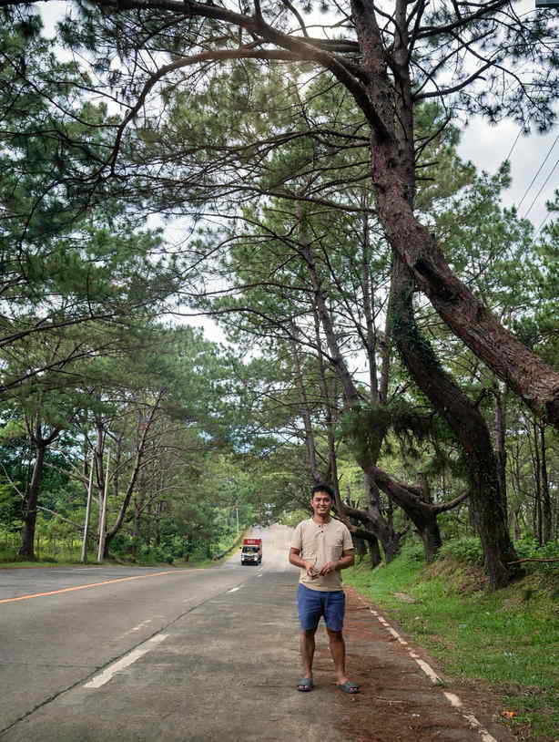
The scene most people picture when they hear DSB is the run of tall pines along the highway between Barangay Igmaya-an and the town proper, a little under two kilometres long. There is a pine-planted area beside the road in Igmaya-an where visitors can walk in among the trees. Keep to the shoulder when taking photos, because buses and trucks come round the bends with little warning.
Pineapples by the roadside
Fruit vendors set up near the pine area and slice pineapples on the spot. They are known for being sweet, and a whole fruit makes an easy snack for the rest of the ride or something to carry down to Bacolod. Bring small bills.
The view deck
A roadside viewpoint with a lion statue looks over the forest, a small set of rice terraces and the Talos River valley. On clear mornings Mount Kanlaon shows up on the horizon. This is also where you register and pay the environmental fee if you plan to walk down to the falls.
If You Have Half a Day or Stay the Night
Malatan-og Falls, in Barangay Kumaliskis, is the main reason to stretch the stop. The trail starts from the highway and drops for about 30 to 45 minutes, steep in places, to a pool where you can swim. A guide from the protected area office of the Northern Negros Natural Park is required, and they are assigned when you register at the view deck. The walk back up is the hard part, so wear shoes with grip and carry water. Bring out every piece of trash you carry in.
The Maglahos River Tunnel is a rock passage cut by the river, reached by a downhill walk and a few ankle-deep crossings. Go with a local guide who knows the water level that day.
Closer to San Carlos, near Barangay Prosperidad, a cluster of grassy, cone-shaped hills looks like a smaller cousin of Bohol's famous ones. They sit just off the route and make a quick stop for anyone heading to or from the port.
Places to sleep are limited to a handful of mountain resorts, retreat houses and private villas listed online. Book ahead for weekends and the hot months of the dry season, when the cool weather is the main draw. Pack a light jacket for the night.
Weather, Kanlaon and Other Honest Notes
DSB is wet. The rainiest months run from June to October, and February tends to be the driest. Fog makes the pines look beautiful but ruins the long views, so aim to arrive in the morning if the scenery is the point. Trails to the falls get slippery after rain and may be closed when rivers run high, so ask at the view deck first.
The bigger issue is the volcano. DSB is on the northern flank of Mount Kanlaon, which erupted on 10 October 2026. Light ashfall reached seven of the town's barangays, including Igmaya-an and Kumaliskis, and Phivolcs kept Alert Level 2 in place, with the four-kilometre permanent danger zone around the summit closed to everyone. The highway and the town are well outside that zone, but conditions can change quickly. Our guide to Kanlaon alert levels and what they mean for visitors explains what each level means. Check the latest Phivolcs bulletin on the morning you travel, carry a face mask in case of fresh ash, and skip river trails during heavy rain, when lahar can run down channels near the volcano.
DSB is a small upland town, so arrive with enough cash for fees, guides, food and the onward fare rather than counting on cards.
Fitting DSB Into the Wider Trip
For a trip coming over by sea, the simplest plan is an early boat into San Carlos, a bus up the mountain, a few hours in DSB and an afternoon run down to Bacolod in time for dinner. Our guide to Philippine ferry routes and booking covers the Toledo to San Carlos crossing, which takes about two hours. Heading the other way, leave Bacolod early, stop in DSB for the morning and catch a midday or afternoon boat out of San Carlos.
Murcia sits on the same highway, lower down toward Bacolod, so anyone who wants a second mountain stop can pair DSB with a day trip to Mambukal Resort and its warm sulfur pools. After that, the cane fields take over again all the way to the city.
Comments
No comments yet. Been here recently? Share a tip or ask a question.
Leave a Reply